


COPYRIGHT©2022 MUHANIT. ALL RIGHTS RESERVED. Designed by WebSite.co.kr
HOME >BUSINESS > NEWSROOM
NEWSROOM
MUHANIT, Artificial intelligence and spatial information platforms come together
관리자
2020-05-19
Number of views 229,090
Companies recognized for their best performance and expertise in each field of spatial information will contribute to the development of the public administration sector with national land management platforms that apply their own technologies.
MUHANIT (CEO Bae Kyung-Rok), a company specializing in intelligent spatial information services, announced that it signed an MOU with a representative company of drones, 3D platforms, and precision road maps on February 21 in line with the declaration of "Artificial Intelligence (AI) Government."
CEO Bae Kyung-Rok said, "This strategic platform allows lifecycle management of almost all space areas that can be managed by platforms such as smart cities, smart construction, and smart farming," and added, "We are proud to have contributed to the safety of the city by managing the entire cycle from the creation of roads in Gyeonggi Province and Seoul." He said, "We have established objective diagnostic capabilities that only spatial information and artificial intelligence can do in corrective operation, and for safety, there must be a platform that is easy to obtain and share spatial information."
It is predicted that the so-called intelligent geo AI platform will be divided into facilities, land, and environmental management and will be named SMART LEMS, SMART RATS, and will be able to strengthen the social safety net through active information exchange with local governments.
MUHANIT said SMART LEMS will be able to support the search and action of problems necessary for construction, agriculture, state maintenance, and forest administration through AI learning of satellite and drone acquisition images, and SMART RATS will be able to manage everything related to the road's life cycle.
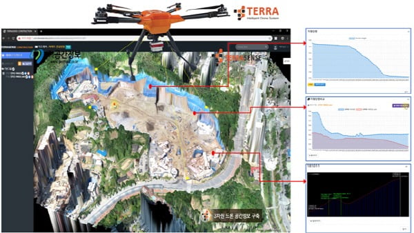
In particular, SMART LEMS acquires 3D data through real-time drone shooting at construction sites, and shares information on smart Rams by construction stage such as topographic survey, soil volume calculation, and process management. It is expected that on-site safety will be applied to construction, urban areas, and disaster safety areas, which are directly related to process efficiency, to change the appearance of field work in the future.
The four companies that participated in this agreement with MUHANIT are EGIS Co., Ltd., a company specializing in 3D GIS platforms, and UAV (drone) production. Space Information Co., Ltd., a company specializing in remote exploration, and Mobile LiDAR Scanning (MMS) precision road map using 3D LIDAR are UOK Co., a company specializing in remote exploration.
Each company plans to combine and cooperate with unique technologies in different fields to commercialize intelligent service models (SMART LEMS) in the land, environment, facilities, and disaster areas by 2021.
[Original article]
- Old post
- There is no old post.
MuhanIT CO.,
Registration # : 873-88-00217 CEO : KyungRok Bae, MyungHwa Lee
HQ : #706, 12, Dangsan-ro 2-gil, Yeongdeungpo-gu, Seoul, Republic of Korea Direction
Branch : 2th floor, 154, Pilmun-daero, Dong-gu, Gwangju, Republic of Korea
T. 02-6952-0825 F. 02-6952-0826 E. admin@muhanit.kr Privacy Policy
Registration # : 873-88-00217 CEO : KyungRok Bae, MyungHwa Lee
HQ : #706, 12, Dangsan-ro 2-gil, Yeongdeungpo-gu, Seoul, Republic of Korea Direction
Branch : 2th floor, 154, Pilmun-daero, Dong-gu, Gwangju, Republic of Korea
T. 02-6952-0825 F. 02-6952-0826 E. admin@muhanit.kr Privacy Policy
